Risks and problems this service helps prevent
Digging without reliable service information can lead to electrical strikes, damaged water or gas lines, interrupted communications, flooding, fire, injury and costly emergency repairs. Existing plans are valuable, but they may be incomplete, outdated or unable to show the exact onsite position and depth of a service.
Utility damage can stop a project immediately and trigger repairs, investigations, utility-provider involvement and significant delays. It may also affect neighbouring properties, operating facilities or critical infrastructure well beyond the excavation area.
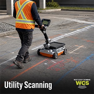
Professional utility scanning gives the project team clearer information for planning excavation routes, exclusion zones and verification points. No single locating method can guarantee every buried object, so findings should be combined with current plans, permits, site knowledge and physical verification such as potholing where required.
What can be detected or assessed?
- Traceable electrical and communications cables
- Metallic water, gas and service pipes
- Some non-metallic pipes or disturbed ground using GPR where conditions permit
- Service routes, changes in direction and likely connection points
- Approximate depths where reliable readings are available
- Underground pits, ducts and related utility features
Typical projects and industries
- Civil construction and roadworks
- Commercial and industrial developments
- Trenching, excavation and directional drilling
- Electrical, plumbing and communications installations
- Mining, infrastructure and regional projects
- Facilities maintenance and property upgrades
How the process works
- Available plans, service records, access points and the proposed work area are reviewed.
- A visual inspection identifies pits, meters, valves, cabinets and other useful surface clues.
- Electromagnetic locating is used in suitable active and passive modes to trace conductive services.
- GPR may be used to investigate non-conductive utilities, confirm alignments or identify additional subsurface features.
- Detected routes and approximate depths are marked onsite, and findings and limitations are explained to the client.
What the customer receives
- Clear onsite markings of detected utility routes
- Approximate depths where reliable readings can be obtained
- A verbal briefing on findings, uncertainties and limitations
- Site photographs or marked-up information where requested
- A written locating report where included in the agreed scope
Why West Coast Scanning is well positioned to help
West Coast Scanning provides direct, owner-operated utility scanning with more than 12 years of practical industry experience. Chris works directly with builders, civil contractors, electricians, plumbers and project managers, so information does not disappear into a large booking system before reaching the person completing the work.
We are known for fast responses, competitive rates and a flexible approach to metropolitan and regional projects throughout Western Australia. Free quotes, quality GSSI and electromagnetic locating equipment, personal attention and same-day results and invoicing where possible help keep projects moving. Regular clients return because the service is straightforward, responsive and useful onsite. The complimentary mug is a small bonus, but a surprisingly popular one.
Frequently asked questions
What types of utilities can you locate?
Depending on access, materials and site conditions, locating may identify electrical, communications, metallic water and gas services, ducts, drainage and some non-metallic utilities using GPR.
Can you rely on service plans alone?
Plans are an important starting point, but they may be incomplete, outdated or diagrammatic. Onsite locating helps assess the actual position of detectable services.
Can you provide exact depths?
Depth estimates may be available for some services, but accuracy depends on the locating method, target, ground conditions and signal quality. Physical verification may still be required.
Can you locate PVC pipes?
GPR may detect some PVC or non-metallic pipes when soil conditions, pipe size, depth and contrast are favourable. Detection cannot be guaranteed in every situation.
Do you service regional WA?
Yes. West Coast Scanning works throughout Western Australia. Send the site location, scope and required date so travel and scheduling can be included in the free quote.